GeoView Desktop Edition
Capture, share and view georeferenced imagery and videos using desktop environment
MOBILE MAPPING ON YOUR DESKTOP
Capture, share and view recorded georeferenced imagery and videos using standalone application or AutoCAD add-in
GeoView Desktop edition enables capturing, sharing and viewing georeferenced imagery and video using various desktop client environments and host applications. It is intended for offices and buros who need their recordings and meta-data overlayed with existing drawings and displayed in AutoCAD, Map 3D, Civil 3D, or viewed in standalone application.
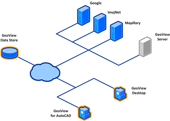
Software application may run on a single workstation, as well as within LAN boundaries where multiple users share their imagery and video recordings using common geospatial datastore, or use GeoView Enterprise provider in corporate environments. You may utilize built-in set of file-based (photo and video) and web-based (Google StreetView, Imajnet, Mapillary…) imagery providers, or even create a custom one using rich GeoView API toolset.
STANDALONE APPLICATION
![]()
Standalone application lets you run GeoView on just about any Windows hardware configuration.
It’s suitable for both single workstations and larger group of users running within LAN or WAN environments. Application enables inspecting georeferenced photo or video recordings using popular background map providers such as Google Maps, Bing Maps, OpenStreetMap Maps… as well as local map providers like AGIV.
Besides displaying your own recordings, GeoView provides access to public and commercial on-line imagery providers such as Google StreetView, Imajnet, Mapillary and others. Standalone application also makes it easy to reproject and export specific recordings to numerous spatial raster and vector formats (SHP, GPX, GML…)
AUTOCAD PLUG-IN
![]()
AutoCAD plug-in enables running GeoView inside your preferred Autodesk CAD/GIS environment.
Highly suitable for CAD-enabled workstations or engineering buros, lets you import, view and share georeferenced photo/video recordings on AutoCAD, AutoCAD Map 3D and AutoCAD Civil 3D platforms. It overlays currently opened drawing with recording location glyphs, enabling user to view them and inspect their properties using GeoView palette.
Plug-in also enables on-the-fly reprojection of recordings’ coordinates into your current drawing’s spatial reference system. It also provides ways of interactively embedding recorded imagery directly into drawing, creating automated imagery reports out of series of recordings, support for customizable report templates, and many more.