What Is GeoView?
CREATE YOUR OWN MOBILE MAPPING CLOUD
GeoView represents specialized client/server solution for collecting, sharing and publishing georeferenced imagery and videos.
Today’s mobile mapping platforms commonly rely on proprietary, off-site, pay-as-you-go platforms and technologies – making it hard for both corporate environments and individuals capturing their own, in-house georeferenced imagery datasets. This does not pose only security concerns, but also involves unnecessary costs and expensive data plans. Moreover, with GeoView it’s you who decide which data to capture, how, where and when.
GeoView also comes with unique, built-in support for 3rd party providers of mobile imagery services such as Google StreetView and others. GeoView API enables customizing it further to continue using your provider of preference, along your in-house datasets. It’s scalable architecture enables both desktop and enterprise deployments, spanning from a single workstation to your corporate LAN/WAN or global Internet service. Based on required level of resilience, GeoView comes in three editions: Enterprise, Desktop and Mobile.
COLLECT.
Use any GPS-enabled recording device to collect still photos or georeferenced videos. Supported devices span from your mobile phone camera to professional-grade GPS recorders. GeoView processes and stores collected content and meta-data using specialized geospatial database.
SHARE.
Share the collected information with your colleagues, co-workers or the crowd and let them take advantage of the in situ documentation you created. The data can get shared in a private cloud – using GeoView Enterprise installed on your own server(s) – or the public cloud by uploading the dataset to our servers
CONSUME.
Published GeoView datasets may get consumed using wide range of clients, including GeoView for AutoCAD where you can combine resulting content with existing drawings. Enterprise architecture also enables consuming data using WMS or WFS services and utilizing GeoView Server API either within your LAN/WAN or via Internet.
GeoView Editions
Choose software architecture that suites your environment best
ENTERPRISE
GeoView Enterprise edition enables running your corporate “cloud” solution for georeferenced imagery and video capturing, sharing and publishing. Leave security concerns behind, as your sensitive data stays behind your company’s firewall. It is you who decide how, what, where and when gets recorded, and which users and departments may gain access to recorded material. Manage and share data accross specified domain boundaries, or choose to publish over Internet via wide range of available services. Versatile GeoView API enables intergration with your existing solutions and building custom data providers.
DESKTOP
GeoView Desktop edition enables capturing, sharing and viewing georeferenced imagery and video using various desktop client environments. It is intended for offices and buros who need their recordings and meta-data overlayed with existing drawings and displayed in AutoCAD, Map 3D, Civil 3D, or viewed in standalone application. Share your data with colleagues using common geospatial datastore, or use GeoView Enterprise provider in corporate environments. Create photobooks in DWG drawings, export recorded imagery as AutoCAD features or to multiple file formats, save imagery directly to hard disk, and more.
MOBILE
GeoView Mobile edition helps users capture and share georeferenced imagery and video using iPhone/iPad or Android smartphones. Mobile application records and uploads captured recordings to GeoView Enterprise server, enabling you share captured data with your friends and colleagues. Moreover, smartphone application helps you analyse driving, cycling, or walking routes using the statistics recorded with each GPS-enabled video. Once uploaded to GeoView server, data is immediately available for publishing and consuming on desktop platforms.
Industries And Applications

SURVEYING
Plan your geodetic surveys using site imagery from database. Improve your existing AutoCAD drawings with photobooks of entire site or specific details. Validate surveyed objects using visual checkup against site photos.

RAILWAY NETWORKS
Manage railway infrastructure assets and keep track of its condition. Create and run fixtures and equipment inventory (semaphore and light signals, junction indicators, banners). Perform risk analysis. Plan railway maintenance.

ROAD NETWORKS
Validate existing road infrastructure asset and condition data. Check quality of road pavement. Plan your maintance according. Verify the visibility and status of traffic signs. Do they need to be moved, cleaned or replaced?

PUBLIC WORKS
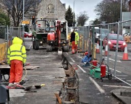
Track public infrastructure works in progress and keep performance record of work done. Plan events ahead ensuring there are no physical obstacles. Establish inventory for budget planning. Facilitate communications with field staff and public.

LEISURE & FUN
Keep track of your rides, manage your walks in the wood or create touristic information for your municipality. Share it with others using social media or use it to attract people to come and visit the region. Municipalities can overlay their GIS data with created content in their environment of preference

DISASTER MANAGEMENT
Provide disaster management, planning and response operations. Adapt relief actions based on actual field data collected after catastrophe has occured. Compare pre- and post-disaster imagery to create timely damage assessment reports.

TELECOM NETWORKS
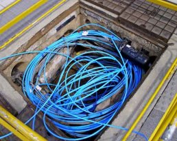
Plan, build and manage your telecommunications infrastructure while keeping track of execution performance using database imagery. Perform visual inspection of passive OSP telco equipment: cabling, antennae, manholes, poles, towers…

UAVs & DRONES
Make use of UAV-mounted camera to assess and track hardly reachable locations. Utilize video recordings for geodesy and infrastructure planning, execution and maintenance, as well as emergency and distaster planning and management.
Samples and Tutorials
SERVER & WEB CLIENT INSTALLATION
Video tutorial on GeoView Enterprise step-by-step installation and environment configuration procedure, including GeoView Server and Web Client components.
CREATE PHOTO REPORTS
Video tutorial on creating imagery reports using GeoView for AutoCAD. Reporting functionality enables creating Word Document (.docx) reports using a drawing containing checked-out GeoView recordings and actual imagery raw data.
MAKING MAP SNAPSHOTS
Video tutorial on creating geo-referenced map view snapshots using GeoView Desktop. Resulting map imagery can get inserted into AutoCAD Civil 3D, AutoCAD Map 3D or any other GIS application capable of displaying geo-referenced rasters.
CREATE EMPTY DATASTORE
Video tutorial on creating an empty GeoView data store. Resulting FDO-compatible data store keeps future recordings’ meta-data, and can be deployed on local computer or LAN/WAN – fully compatible with AutoCAD Civil 3D and AutoCAD Map 3D.
RAILWAY INDUSTRY CASE
Video tutorial on utilizing GeoView Desktop in railway industry via ImajNet imagery provider. Provides hints on GeoView deployment in railway infrastructure inspection and maintenance for Imajing services subscribers.
AUTOCAD PHOTOBOOK
Video tutorial on creating photobooks using GeoView for AutoCAD. Photobook feature enables copying specified camera view into currently opened drawing, letting you create more elaborate civil engineering projects.
GeoView Support
Get support any time, anywhere
GeoView customer support and technical services staff understands that without proper application installation, configuration, and maintenance users risk additional costs due to delays in implementation, inefficiency caused by slow software performance, and process issues as a result of lost or missing data. Our experienced team can help ensure that software products are installed, configured, and maintained so you can focus on what you do best.
Reseller Support
GeoView resellers offer service, insight, training, and support wherever our customers live and work across the world. They provide everything from telephone support to disaster recovery, industry-specific training, networking and integration, flexible purchase options, and technical expertise.
Become a Reseller
We are always looking for talented partners with industry and technical expertise, and a strong focus on customer service. Please contact us for becoming a GeoView reseller.
Technical documentation
Technical documentation, assisting users utilizing GeoView software products, is provided in both off-line and on-line data formats. Provided manuals include user’s manuals, products’ best practices, detailed products’ guides, video tutorials, and many more. Depending on the software product and your subscription status, manuals may get provided in multiple formats: Adobe PDF, Microsoft Word, CHM Help, EPub EBook, Mobipocket and Kindle EBook. GeoView also provides publicly available, web-based on-line help system.
Developer Support and On-line Help
GeoView provides guidance to get your third-party solutions to market more quickly by providing you with access to our API expert engineers. Our professionals have years of experience working with third-party solutions, and possess in-depth knowledge around the intricacies of the GeoView Core, REST and SOAP APIs. Sample code, general recommendations and coding best practices get provided to express a suggested solution. GeoView also exposes publicly available, on-line API reference.


